Under New Management Formerly ALPINErvcamping.com
About Skagit River RV & Camping
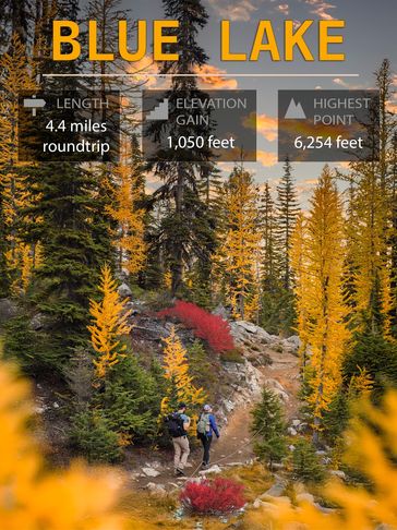
Blue Lake Trail
Washington Pass Overlook
North Cascades > North Cascades Highway - Hwy 20
Coordinates: 48.5191, -120.6742
Length 4.4 miles, roundtrip // Elevation Gain 1,050 feet // Highest Point 6,254 feet
Directions: Approaching from the west, drive 42.1 miles from Newhalem on Highway 20 and find the trailhead on the right. If you pass the Washington Pass Overlook, you have go
North Cascades > North Cascades Highway - Hwy 20
Coordinates: 48.5191, -120.6742
Length 4.4 miles, roundtrip // Elevation Gain 1,050 feet // Highest Point 6,254 feet
Directions: Approaching from the west, drive 42.1 miles from Newhalem on Highway 20 and find the trailhead on the right. If you pass the Washington Pass Overlook, you have gone too far. From the east, drive 31.3 miles from Winthrop on Highway 20 and find the trailhead on the left a little under a mile past the Washington Pass Overlook. A privy is available at the trailhead.
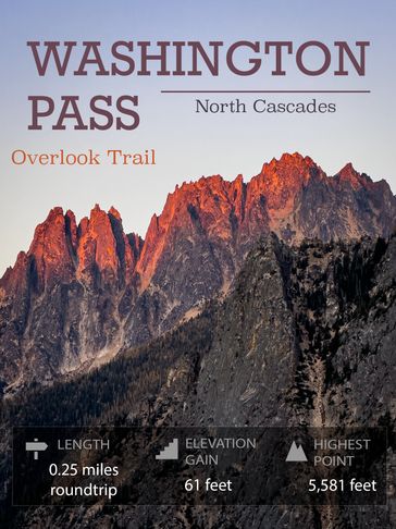
Washington Pass Overlook
Washington Pass Overlook
North Cascades > North Cascades Highway - Hwy 20
Coordinates: 48.5245, -120.6581
Length 0.25 miles, roundtrip // Elevation Gain 61 feet // Highest Point 5,581 feet
Directions: From Newhalem, on Highway 20, travel eastbound about 44 miles to Washington Pass. The Overlook parking lot is on the north side of the road (or left when traveling
North Cascades > North Cascades Highway - Hwy 20
Coordinates: 48.5245, -120.6581
Length 0.25 miles, roundtrip // Elevation Gain 61 feet // Highest Point 5,581 feet
Directions: From Newhalem, on Highway 20, travel eastbound about 44 miles to Washington Pass. The Overlook parking lot is on the north side of the road (or left when traveling eastward). Drive into the overlook area about a quarter-mile until a fancy, prominent building is on your left. Park here by the picnic tables. The trailhead is by the kiosk in the direction from which you came.
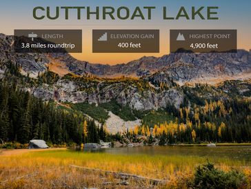
Cutthroat Lake
Cutthroat Lake
North Cascades > North Cascades Highway - Hwy 20
Coordinates: 48.5563, -120.6547
Length 3.8 miles, roundtrip // Elevation Gain 400 feet // Highest Point 4,900 feet
Directions: From I 5, take Highway 20 across the North Cascades, enjoying the beautiful scenery along the way. Cross both Rainy and Washington Pass, and after the hairpin turn,
North Cascades > North Cascades Highway - Hwy 20
Coordinates: 48.5563, -120.6547
Length 3.8 miles, roundtrip // Elevation Gain 400 feet // Highest Point 4,900 feet
Directions: From I 5, take Highway 20 across the North Cascades, enjoying the beautiful scenery along the way. Cross both Rainy and Washington Pass, and after the hairpin turn, near milepost 167, look for Cutthroat Creek road 400, signed Cutthroat Lake trailhead. Turn left and drive a mile on the good gravel road to the end and trailhead. There is a large parking lot and a vault toilet.